antique map of britain under the anglo saxons - saxon map stock illustrationsAntique map of Britain under the Anglo SaxonsMap, Anglo-saxon, England
map of anglo-saxon kingdoms and the danelaw, 9th century - saxon map stock illustrationsMap of Anglo-Saxon Kingdoms and the Danelaw, 9th CenturyMap, Anglo-saxon, England
Britain in 792 A.D. Showing: Northumbria, Offas Supremacy, East Anglia, West Saxon Supremacy, Dyvnaint, North Welsh, Northumbria.Britain in 792 A.DAnglo-saxon, Map, England
England, Scotland and Ireland - Time of Viking Invasions', 1926. Map of Britain during the 9th-11th century. 'Towns of Viking foundation in Ireland...EnglandViking, Map, Ireland
Map showing the Heptarchy . The name applied to the Anglo-Saxon kingdoms of south, east, and central England during late antiquity and the early...Map showing the Heptarchy (from the Greek hepta, seven). The name applied to the Anglo-Saxon kingdoms of south, east, and central EnglandAnglo-saxon, Map
Danish Invasion of Wessex 876-878', . Map of England, Wales and part of Scotland, showing significant locations during the invasions from...Danish Invasion Of Wessex 876-878
antique map of cambridgeshire - saxon map stock illustrationsAntique map of CambridgeshireMap, Cambridge, UK
Map showing the Heptarchy . The name applied to the Anglo-Saxon kingdoms of south, east, and central England during late antiquity and the early...Map showing the Heptarchy of Britain.Map, Anglo-saxon
Map of England Showing the Anglo-Saxon Kingdoms and Danish Districts.Map of England Showing the Anglo-Saxon Kingdoms and Danish Districts.
The Destruction of Roman Britain', 1926. Map of Britain showing invasions towards the end of the Roman period . 'The arrows indicate the general...The Destruction Of Roman BritainMap, UK, Rome - Italy
Britain As It Was Devided In The Tyme of the Englishe Saxons especially during their HeptarchyPrivate CollectionUK, 17th Century, Map
Map of Britain at the time of the Saxon Heptarchy. Published in Speed's 'The Theatre of the Empire of Great Britain', 1611. Anglo- Saxon kingdoms of...Map of Britain at the time of the Saxon HeptarchyAnglo-saxon, Map, England
old map of england, showing the anglo-saxon kingdoms and the danish districts (the latter shaded) - saxon map stock pictures, royalty-free photos & imagesOld map of England, showing the Anglo-Saxon Kingdoms and the Danish districts (the latter shaded)Anglo-saxon, Map
Map of England, Showing the Anglo-Saxon Kingdoms and the Danish Districts ', , 1890. The Heptarchy is a collective name applied to the seven kingdoms...Map Of EnglandMap, Anglo-saxon, England
british history 6th century, map of britain in 593 ad showing the saxon kingdoms of england - saxon map stock illustrationsBritish history 6th Century, Map of Britain in 593 AD showing the Saxon Kingdoms of EnglandMap, Kingdom - Location, North East England
Athelney & Ethandun 878', . Map of part of the west of England , showing Athelney, which was once the fortress hiding place of King Alfred the Great....Athelney And Ethandun 878Map, Anglo-saxon
Shields of Sussex, Kent and Essex from the Heptarchy; a collective name applied to the Anglo-Saxon kingdoms of south, east, and central England...Shields of Sussex, Kent and Essex from the Heptarchy; a collective name applied to the Anglo-Saxon kingdoms of south, east, and central England during late antiquity and the early Middle Ages
Map Of England Showing The Anglo-Saxon Kingdoms And Danish DistrictsMap Of England Showing The Anglo-Saxon Kingdoms And Danish DistrictsAnglo-saxon, England, Map
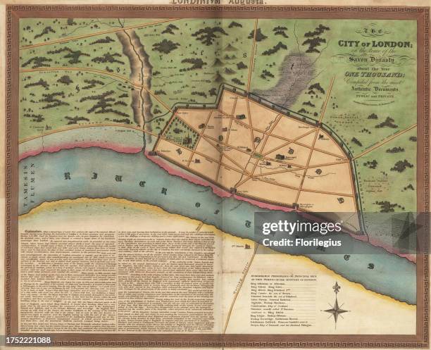
Map of London in the Anglo-Saxon era, circa 1000 AD. Walled town with Palace of King Athelstan, churches, gates , surrounded by fields, wells, and...William DartonLondon - England, Roman, Map
map of britain and the english conquest, the anglo-saxon invasion, 5th century - saxon map stock illustrationsMap of Britain and the English Conquest, The Anglo-Saxon Invasion, 5th CenturyUK, Map, Road Map
saxon duchies, principalities schwarzburg and reuss (germany), lithograph, 1897 - saxon map stock illustrationsSaxon duchies, principalities Schwarzburg and Reuss (Germany), lithograph, 1897Map, Germany, Weimar
Atlas, map from 1623, Northumbria, one of the Anglo-Saxon petty kingdoms of England, digitally restored reproduction from an engraving by Gerhard...Atlas
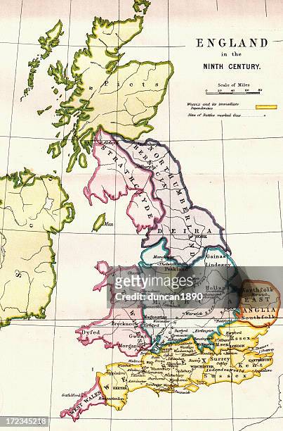
england in the ninth century - saxon map stock illustrationsEngland in the Ninth CenturyMap, England, Medieval
Map of the Vikings & Western Christendom in the Ninth Century', . Modern map showing territories occupied, controlled or raided by the Vikings . From...Map Of The Vikings And Western Christendom In The Ninth CenturyMap, Viking, Europe
"Britain as it was devided in the Tyme of the Engshe Saxons especially during their Heptarchy. Pub. George Humble and John Sudbury, London. With 14...Map of Great Britain Surveyed by John Speed and Engraved by Jocodus HondiusMap
Shield of Scotland, from the Heptarchy; a collective name applied to the Anglo-Saxon kingdoms of south, east, and central England during late...Shield of Scotland, from the Heptarchy; a collective name applied to the Anglo-Saxon kingdoms
signs exaggeration, york, england - saxon map stock pictures, royalty-free photos & imagesSigns exaggeration, York, EnglandChaos, Information Stand, Map
vintage anglo‑saxon map of england and brittany — antique historical cartography illustration - saxon map stock pictures, royalty-free photos & imagesVintage Anglo‑Saxon Map of England and Brittany — Antique Historical Cartography Illustration
Britain in 593 A.D. Showing the kingdoms of Britain: Northumbria, Supremecy ogf Aethelberth, East Engle and West Saxon.Britain in 593 A.D
Shields of Sussex, Kent and Essex from the Heptarchy; a collective name applied to the Anglo-Saxon kingdoms of south, east, and central England...Shields of Sussex, Kent and Essex from the Heptarchy.Map, Anglo-saxon
This map shows Britain in the 9th century A.D. The legend has yellow as representing Wessex and its immediate dependencies. A plus-sign marks the...England in the Ninth Century
window on the world - una finestra sul mondo - saxon map stock pictures, royalty-free photos & imagesWindow on the world - Una finestra sul mondoGlobe - Navigational Equipment, World Map, Anglo-saxon
Map Of Britain In 792. The Three Kingdoms 685 To 828. From The Book Short History Of The English People By J.R. Green, Published London 1893Map Of Britain In 792England, Map, UK
Shield of Mercia, from the Heptarchy; a collective name applied to the Anglo-Saxon kingdoms of south, east, and central England during late antiquity...Shield of Mercia, from the Heptarchy; a collective name applied to the Anglo-Saxon kingdoms
This map shows Britain at the time when it was in the middle of the English Conquest, fron the fifth century A.D. To the 11th century A.D. The blue...Britian in Midst of English Conquest
Shield of Northumberland, from the Heptarchy; a collective name applied to the Anglo-Saxon kingdoms of south, east, and central England during late...Shield of Northumberland.Map
Part of Rome. From a plan drawn c.1475', . Medieval map of the city of Rome, Italy, showing the walls and Roman Colosseum, . From A History of the...Part Of Rome From A Plan Drawn C1475Map, Rome - Italy, Circa 15th Century
Shield of Northumberland, from the Heptarchy; a collective name applied to the Anglo-Saxon kingdoms of south, east, and central England during late...Shield of Northumberland, from the Heptarchy; a collective name applied to the Anglo-Saxon kingdomsMap, Medieval, England
Shield of Wales, from the Heptarchy; a collective name applied to the Anglo-Saxon kingdoms of south, east, and central England during late antiquity...Shield of Wales, from the Heptarchy; a collective name applied to the Anglo-Saxon kingdoms
Shield of East Anglia, from the Heptarchy; a collective name applied to the Anglo-Saxon kingdoms of south, east, and central England during late...Shield of East Anglia, from the Heptarchy; a collective name applied to the Anglo-Saxon kingdoms
Shields of Wessex and Sussex from the Heptarchy; a collective name applied to the Anglo-Saxon kingdoms of south, east, and central England during...Shields of Wessex and Sussex from the Heptarchy; a collective name applied to the Anglo-Saxon kingdoms
Map of Britain in 665, . An illustration from A Short History of the English People, by John Richard Green, illustrated edition, Volume I, Macmillan...Map of Britain in 665, (1892).
Anglo-Saxon world map, 10th century. A map showing a flat Earth and the ocean that was thought to surround it. From the British Museum.Anglo-Saxon world map, 10th century.
russia engraving antique illustration, published 1851 - saxon map stock illustrationsRussia Engraving Antique Illustration, Published 1851Agriculture, Plan - Document
russia engraving antique illustration, published 1851 - saxon map stock illustrationsRussia Engraving Antique Illustration, Published 1851Russia, Map, Russian Culture
Shields of Wessex and Sussex from the Heptarchy; a collective name applied to the Anglo-Saxon kingdoms of south, east, and central England during...Shields of Wessex and Sussex from the Heptarchy.Map
Alfred's Last War - Third Phase, 893. April to June', . Map of the south-east of England, showing 'Burhs' of the Anglo-Saxon King Alfred the Great,...Alfreds Last War - Third Phase
Alfred's Last War - Opening Phases. From about October 892-March 893', . Map of the south-east of England, showing 'Burhs' of the Anglo-Saxon King...Alfreds Last War - Opening Phases From About October 892-March 893Map, Denmark
The Cottoniana or Anglo-Saxon Map ', c995, . The map is part of the 11th century illuminated manuscript Cotton Tiberius, held by the British Library,...The Cottoniana Or Anglo-Saxon Map
Ælla King of Northumbria, England in the middle of the 9th century. Sources on Northumbrian history in this period are limited. Detail from an...Ælla (died 21 March 867) King of Northumbria, England in the middle of the 9th century.
The Pillars of Hercules, as shown in the Anglo-Saxon map of the world, tenth century.The Pillars of Hercules, as shown in the Anglo-Saxon map of the world, tenth century.
Germany - Saxony - Rathen: Asian tourists in front of a map at the Saxon SwitzerlandGermany - Saxony - Rathen: Asian tourists in front of a map at the Saxon Switzerland
Prof. Martin Foys, a Medievalist and English Professor at Drew University speaking at a faculty talk where he discussed his "Digital Mappaemundi"...USA - Digital Humanities - Martin Foys of Drew University
Prof. Martin Foys, a Medievalist and English Professor at Drew University speaking at a faculty talk where he discussed his "Digital Mappaemundi"...USA - Digital Humanities - Martin Foys of Drew University
Map of London during the Saxon period, 1835. The section in the lower left contains descriptive text.Map of London during the Saxon period, 1835. Artist: Anon
Map of London during the Saxon period, c1000.Map of London, c1000. Artist: AnonLondon - England, Circa 11th Century, River Thames
Egbert the Saxon, first king of all England. Egbert ruled Wessex from 802. His reign saw Wessex overtake Mercia as the dominant Anglo-Saxon kingdom...Egbert the Saxon, first king of all England.Artist: King
Egbert the Saxon, first king of all England, . Egbert ruled Wessex from 802. His reign saw Wessex overtake Mercia as the dominant Anglo-Saxon kingdom...Egbert the Saxon, first king of all England, (18th century).Artist: George Vertue