Storm Eowyn 20250124 Precipitation Map United Kingdom - stock illustration
Precipitation Weather Map of Storm Éowyn over the North Sea near United Kingdom on January 24, 2025. All source data is in the public domain. Made with data courtesy from Goddard Earth Sciences Data and Information Services Center (GES DISC), NOAA. NCEP/CPC L3 Half Hourly 4km Global Merged IR V1. Countries and Boundaries: Made with Natural Earth.

Get this image in a variety of framing options at Photos.com.
PURCHASE A LICENCE
All Royalty-Free licences include global use rights, comprehensive protection, and simple pricing with volume discounts available
£275.00
GBP
Getty ImagesStorm Eowyn 20250124 Precipitation Map United Kingdom High-Res Vector Graphic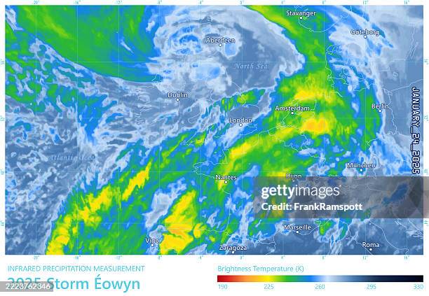 Download premium, authentic Storm Eowyn 20250124 Precipitation Map United Kingdom stock illustrations from Getty Images. Explore similar high-resolution stock illustrations in our expansive visual catalogue.Product #:2223762346
Download premium, authentic Storm Eowyn 20250124 Precipitation Map United Kingdom stock illustrations from Getty Images. Explore similar high-resolution stock illustrations in our expansive visual catalogue.Product #:2223762346£275£50
Getty Images
In stockDETAILS
Credit:
Creative #:
2223762346
Licence type:
Collection:
DigitalVision Vectors
Max file size:
4924 x 3403 px (41.69 x 28.81 cm) - 300 dpi - 12 MB
Upload date:
Location:
United Kingdom
Release info:
No release required
Categories:
- Map,
- Weather,
- Meteorology,
- Radar,
- Rain,
- France,
- January 2025 Storm Éowyn,
- Weather Map,
- Storm,
- UK,
- Atlantic Ocean,
- Data,
- North Sea,
- Temperature,
- 2025,
- Aberdeen - Scotland,
- Calendar Date,
- Cartography,
- City,
- Climate Change,
- Colour Image,
- Computer Graphic,
- Cyclone,
- Danger,
- Digitally Generated Image,
- Dublin - Ireland,
- Emergencies and Disasters,
- Environment,
- Extreme Weather,
- Flood,
- Horizontal,
- Illustration,
- Infographic,
- Infrared,
- Instrument of Measurement,
- January,
- London - England,
- Low,
- National Border,
- Natural Disaster,
- No People,
- Physical Geography,
- Science,
- Scotland,
- Sea,
- Text,
- Threats,
- Time,
- Vector,
- Western Europe,
- Wind,